全球地形起伏模型etopo5
文章目录
etopo5是全球高程及水深数据,其空间分辨率是5弧分,目前已被更高精度的etopo2和etopo1所取代。但在绘制 全球地形时,若觉得用etopo2得到的图形文件过大,也可使用低精度的etopo5,但还是不建议用etopo5。
官方页面: http://www.ngdc.noaa.gov/mgg/global/etopo5.html
下载地址
其中, ETOPO5.DAT 和 ETOPO5.DOS 包含了相同的高程数据,只是二者的字节序不同。 ETOPO5.DOS 为
little-endian , ETOPO5.DAT 为 big-endian 。
网格数据的说明
简单归纳一下:
- 数据采样间隔为5弧分
- 经度上0度到359度55分共计4320个采样点(注意不是0到360度),维度方向-90度到90度为2161个点
- 每个数据用16位整数表示,即占用两字节,共计4320*2161*2=18671040字节
- 实际数据中只有18662400字节,这是因为数据中把-90度的南极给丢了,后面会做简单处理,把南极点补回来;
- 数据在文件中的排序很简单,从北纬90度,东经0度0分开始,接下来是360度*12采样点/度=4320采样点, 即8640个字节,一直到北纬90度,东经359度55分;第4321个点为北纬89度55分,东经0度0分,按照这样的顺序 不断排下去。每个纬度带4320个点,共计2160个纬度带。
- 北纬90度即北极,4320个点具有相同的值,为-4290m;南纬-90度即南极,没有包含在这个数据中,其海拔为2810 m。
数据的小修改
如前所说,数据中把南极丢了,这是个小问题,当绘制全球数据时会出现类似“南极海拔不一致”的警告,虽说 不是致命错误,还是改了吧,源代码如下:
/*
 * A simple C code to add the elevation of south pole to the ETOPO5 data
 * Date:   04/30/2013
 * Author: SeisMan
 *
 * Input:  ETOPO5.DOS
 * Output: etopo5.i2
 * Note: ETOPO5.DOS is little-endian;
 *       ETOPO5.DAT is big-endian;
 */

#include<stdio.h>
#include<stdlib.h>
#define NX 4320
#define NY 2160

short int **imatrix(int nrl,int nrh,int ncl,int nch);

int main(){
  short int **topo;
  int ix, iy;
  FILE *fip, *fop;

  topo=imatrix(1,NX,1,NY+1);

  fip=fopen("ETOPO5.DOS","rb");
  for(iy=1;iy<=NY;iy++){
    for(ix=1;ix<=NX;ix++)
      fread(&topo[ix][iy],sizeof(short int),1,fip);
  }

  for(ix=1;ix<=NX;ix++)
    topo[ix][NY+1]=2810;

  fop=fopen("etopo5.i2","wb");
  for(iy=1;iy<=NY+1;iy++)
    for(ix=1;ix<=NX;ix++){
      fwrite(&topo[ix][iy],sizeof(short int),1,fop);
//      printf("%d %d %d\n",ix,iy,topo[ix][iy]);
    }

  close(fip);
  close(fop);
}

short int **imatrix(int nrl,int nrh,int ncl,int nch){
  int i;
  short int **m;

  m=(short int **)malloc((unsigned) (nrh-nrl+1)*sizeof(short int*));
  if (!m) fprintf(stderr,"allocation failure 1 in imatrix()\n");
  m -= nrl;

  for(i=nrl;i<=nrh;i++) {
    m[i]=(short int *)malloc((unsigned) (nch-ncl+1)*sizeof(short int));
    if (!m[i]) fprintf(stderr,"allocation failure 2 in imatrix()\n");
      m[i] -= ncl;
  }
  return m;
}
编译并运行:
$ gcc etopo5_mod.c -o etopo5_mod
$ ./etopo5_mod
复制
将修改后的 etopo5.i2 拷贝至 ${GMTHOME}/share/dbase 下,并在 grdraster.info 中加入如下语句:
1 "ETOPO5 global topography" "m" -R0/359:55/-90/90 -I5m GG i 1 0 none etopo5.i2
这其实也就是默认的 grdraster.info 中的内容,只是GMT没有自带etopo5的数据。
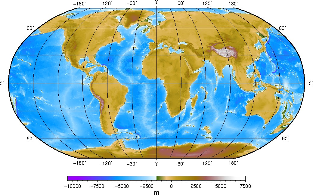
画图检查
#!/bin/bash

gmt grdraster 1 -Rg -I5m -Getopo5_global.grd
gmt makecpt -Cglobe -T-10500/8000/1000 -Z > colors.cpt
gmt grdimage etopo5_global.grd -Ba60g30 -Rg -JN0/25c -Ccolors.cpt -K -Yc > etopo5.ps
gmt psscale -Ba2500f500+l"m" -Ccolors.cpt -Dx12.5c/-1.5c/15c/.35ch -O >> etopo5.ps

rm etopo5_global.grd colors.cpt gmt.*
文章作者 SeisMan
上次更新 2013-08-10